Day 1
Alright, first off welcome to our little trip. Grant and I decided to head out to Death Valley for his Spring Break this year. We flew into Vegas yesterday with the idea of checking out a couple of the local hotspots just outside town (photographic hot spots, just so we’re clear) – tomorrow it’s off to Death Valley.
We woke up to clear skies – never a good sign for a landscape photographer – and decided to head over to Red Rock Canyon. Grant had never been there, and since it was only minutes from the hotel, we thought it would be a cool place to spend our morning.
The temps were cool and the clear skies held the promise of some pretty boring photography. Oh well, can’t win ’em all. However, we did play around with some video – and I tried a little time-lapse moonset with my new Nikon D4 (you’ll see it in the video below).
After watching the sunrise slide down the front of the mountains, we embarked on a ride through the park. We hiked the Calico Hills area and <surprise> Grant had a pretty good time on the rocks. One of these days I’m going to figure out a cool shot for this area…
Next, it was a drive through the canyon (more of a valley really), and back to the hotel to get ready for the rest of the day and grab some of that, umm, “free” continental breakfast action.
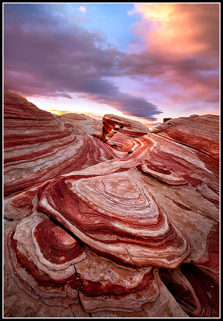
We spent the afternoon over in Valley of Fire State Park, a pretty good hit with Grant. It’s one of my favorite locations, and we hiked 3 or 4 trails as I tried to decide where to shoot that night.
After a lengthy discussion about where to shoot (the debate was in my head – Grant is pretty easy going), I decided to head over to a rock formation called the “Fire Wave.” Not only was Grant excited about checking it out, but it also had some pretty good potential for a photo – a fact that, unfortunately, more and more people are picking up on (makes it sometimes crowded at sunset).
When we arrived, we were lucky enough to have it to ourselves, and I started working it over with the lens, playing with different compositions. The traditional view wasn’t working for me, and it trailed off to a cloudless area of sky.
So I started looking around for a new angle.
I discovered what I thought was a pretty sweet spot opposite the usual area – but there was a problem. What happens if a bunch of other people show up? I’d be right in their shots (and vice-versa) and that wouldn’t be cool. So I setup and waited. A few people showed up but turns out they kind of liked my area better too, so hey, how cool was that?
I’m actually pretty excited about today’s photo (won’t know for sure till I get back – I don’t have a computer with me this time), bit it looks good on the camera. I hope the rest of the trip is this good!
(@ Home Note – LOL – if only I knew what I was in for when I wrote that)
Here’s that day’s video with a host of antics from Grant and myself:
Day 2
No photos this morning (clear again) so it’s time to pack it up and head off to Death Valley National Park!
Unfortunately, not too much to tell today. No epic adventures, no spectacular stories. We pretty much just drove to Death Valley and started looking around for places to shoot.
We arrived too early to check into our hotel room, so we headed to Badwater to see what condition it was in. I keep hoping to hit it when it’s flooded, but alas, not to be this time (I think this is try #8 or #9). Still, we found some pretty nice areas to photograph, so I marked them on the GPS for a possible spot later this week.
Oh, if you’re wondering what Badwater is, it’s an area of salt flats that form into pretty cool polygon-style shapes. It resets itself every time it floods – here’s a shot from a couple of years ago:
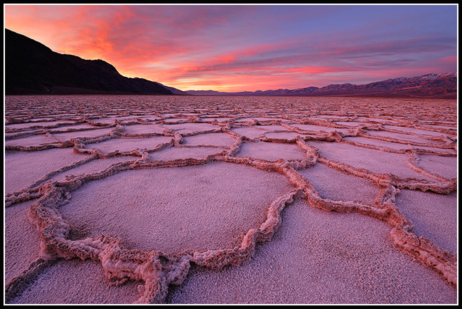
Cool area huh?
It was too early to check in, so we decided to check out the Natural Bridge hike and see if there was anything worth photographing there. Although it was pretty sweet, it’s nothing you’d want to hang on your wall. Still, it was a cool hike and worth seeing.
From there, we decided to do a quick pitstop and drove down Artist’s Drive. I’ve scoped it out many times before and – if the conditions are right – I think I have an area or two that would make for a good photo. However, this trip thorough was mostly to kill a little time and show it off to Grant.
Next, it was off to check into the hotel and drop off our gear. We decided to try Dante’s View for our shot tonight, so we zipped up the mountain and kept our fingers crossed – hoping for some beautiful light and clouds.
BUT –
Yeah, no cool light, so no cool shots. Maybe next time. Fortunately, the forecast is talking about some interesting weather starting late tomorrow… At least we got some video and had a good time
< Warning – goofy fifth grader stuff at the very, very end 🙂 >
Day 3
Wow, day 3 already!
OK, we started off early this morning over at Zabriskie Point keeping our fingers crossed for some sweet clouds and light…
And…
Yeah…
I’m going to stop the whole “crossing my fingers” thing because it just isn’t working. Lots of clouds to the East, nothing over the viewpoint, so another no go. Although, I did learn something important – seems that the best light is more mid-winter (like Dec- Jan) in this area. April finds the sun too far behind the mountains and by the time it breaks the over the tops of ’em the light is already too harsh.
After that, it was back to the hotel for some breakfast and planning. The wind was REALLY picking up so the sand dunes – normally full of tracks – might come into play today.
We hung around the hotel for a bit, had some lunch, and made the decision to head north. The sky looked more promising in that direction, and maybe we’d try heading up to Eureka Dunes to see if we couldn’t squeeze out a photo.
It’s a LONG drive, and I couldn’t help but notice the wind was getting more aggressive the further we went. Luckily, we decided to stop at Ubehebe Crater before heading up to Eureka Dunes. At this point, the wind was so overwhelming I had to pull Grant’s door open for him – he couldn’t push it open against the wind!
As the wind tried to force us back, we made for the crater but were getting stung by flying pebbles! It felt like someone was shooting a BB gun at us as we walked! We decided the best course of action would be to skip the crater for now…
After getting a taste of the wind, it seemed prudent to skip Eureka Dunes. It’s an 80 mile + round trip from where we were on a small, gravel road and if was blowing up there the way it was here, there was just no way to even set up a tripod, much less pull off a photo. We punted on the idea and decided to try Mesquite Dunes instead. They’re not as large and are much more likely to have footprints, but they do have the advantage of being right next to our hotel. If the wind were too bad, we’d just skip it.
We had a little time to kill so we stopped off at Scotty’s Castle to poke around – could be a cool place for star trails one day – then it was time to head back, grab some dinner, and see what the weather was going to do.
As the evening wore on, the wind died down a little and we decided to head out on the dunes and see what we could get. Little did we know that the respite from the gale force winds was only very temporary – it started picking up again shortly after we got the tripod set up. In fact, we did a little video, but we had to use one of my DSLRs – the regular camcorder would have been destroyed with all the blowing sand! (See video)
Fortunately, it was all worthwhile as I was able to grab this shot as the sun was going down:
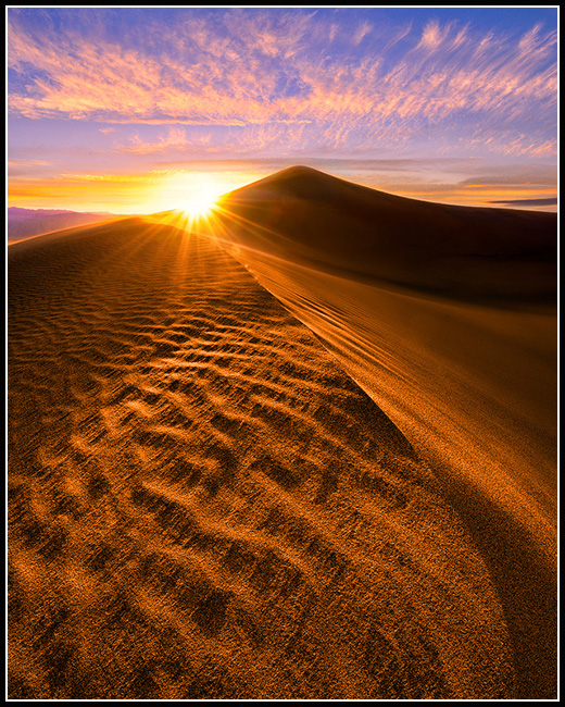
The trip back was pretty rough – once that sun went below the horizon the wind picked up and we were hiking back to the car in a sandstorm. It was only a mile or so, but man, it sure seemed longer! I don’t think I’ve ever been so happy to see a rental car!
Day 4
Sorry, no video today, too windy and WAY too much sand in the air for the poor little camera. That, and the one time we could have used it, we left it in the car. D’Oh!
5:00 AM this morning found us heading out to the dunes in the dark, our path illuminated by flashlight.
As we hiked along in the dim, pre-dawn light, I was thinking about how totally cool it would have been to actually, gee, I don’t know, have a place scouted out to go to this morning! Instead, we were kind of just wandering around in the dark – no plan.
Yup, that’s’ why I like to scout out my morning locations to avoid this EXACT problem, but I was too busy shooting last night to figure something out. Hmm…
So, we made for the same area, just trying to go a little further in. As we looked around for a good spot, the sun was quickly becoming the enemy. I wasn’t spotting anything I really liked, and that ‘ole sun just kept on coming up. Of course, it didn’t help that Grant was nagging away, “Hey Dad, you know it’s getting brighter, right? Hey, Dad, those clouds are starting to look pretty good, where ya gonna shoot? Don’t you think you should have your camera setup by now? Huh? Huh?”
No pressure…
We finally settled on an area, but as of this writing, I’m not sure if it’s a keeper or not. We’ll have to see. If nothing else, it was a decent sunrise, and we used the time out there to our advantage to scout some locations for later.
After about 4 miles of dune hiking, it was time for some breakfast. We went back to the hotel, ate, and got ready for the day.
Next, it was off to Mosaic Canyon. I’ve hiked the area before and I’m convinced there’s a shot there at the right time of year.
This just wasn’t it!
Still, the canyon is always a treat to hike though and if you’re ever in Death Valley, it’s well worth the time. Some areas are, well, a mosaic of different stones all fused together, other areas are like strolling through a canyon made of marble. In fact, one area of rock is so smooth Grant used it as a slide! (That was when we should have had the camera BTW)
Next, it was off to lunch at the saloon at Stovepipe Wells. Best lunch in the valley if you ask me. I’m partial to the Prickly Pear BBQ chicken sandwich, Grant went for the turkey BLT. We enjoyed lunch with some skillful musical accompaniment from a resident piano player.
So, what to do this afternoon? With the wind blowing away footprints as quickly as they formed on the dunes, I wanted to hit those again tonight, but we had some time to kill before then. Hmm, I’ve always wanted to scout out Darwin Falls – perfect!
We took off for the falls and enjoyed the 3-mile round trip hike. There was a bit of rock scrambling to get to it, but overall not too bad (although one guy came out pretty bloody after he took on a slick rock and lost).
The falls itself was in some pretty nasty afternoon light, so no photos. However, now that I know how tight the shooting is, I know what kind of gear to bring next time conditions are right. Score!
After an early dinner, it was back to the dunes. I had really hoped the wind would have blown away all the tracks but turns out that little assessment wasn’t entirely correct. So, we decided to try a smaller area of dunes (that we hadn’t scouted, of course) and try out luck there.
Yeah, bad idea.
Just couldn’t find a composition I liked – but this time, the sky really wasn’t good at all, so nothing lost.
Overall, not the best day of the trip photographically speaking, but we did get find some good areas for the future – and it all starts there.
Day 5
Wow, is it really day 5 already? Time sure flies when you’re out shootin’!
So, the alarm goes off at 4:45AM and it’s time to do my morning check. Regular readers of the blog know that I like to have some clouds in my skies most of the time, so I always check conditions before I drag Grant out of bed. (And I gotta say he’s been pretty good about getting up this time). However, the sky this morning was completely barren – not a cloud in sight anywhere – so we got a little extra (and much needed) rest. These 5:00 AM starts with late bedtimes wear on ya after a few days.
Of course, Grant popped out of bed a couple hours later, looked at the time, and yelled, “Dad! You missed sunrise!!!”
LOL
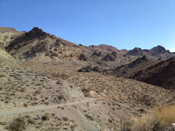
Since the sky was clear and most of the scouting for the trip was done, we decided to try out Titus Canyon. It’s a winding, one-way 4×4 road that takes you through a narrow canyon – at least that was the description.
Little did the brochure prepare us for that drive – it was absolutely fantastic! I can’t believe I haven’t done it before! The road was pretty easy for a 4×4 road (although I’m sure the condition varies) and the views were more than spectacular. Might be a good place to explore with a camera down the road.
Here’s just a snapshot of one of the dozens of views I took with my iPhone:
I could gush on and on about it, but the video takes you through the canyon much better than I can describe it – see below.
Next, it was lunch (yup, my fav – Prickly Pear Chicken again), a quick fill-up, and a trip to the Racetrack.
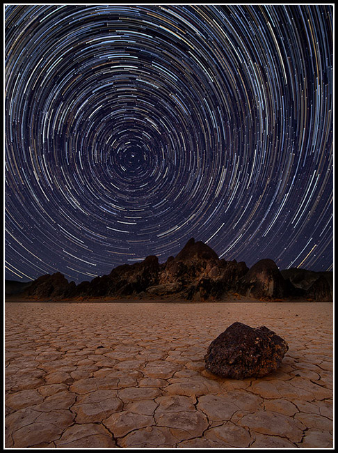
The Racetrack is located in a very remote area of the park – it’s about an hour or so worth of paved road, followed by 27 miles of “knock your fillings out” washboard road. Here’s a dizzying shot I took earlier this year out there:
Getting there is always fun though. I’ve been navigating dirt roads, gravel roads, and 4×4 roads since I started driving, so when I’m trying to get somewhere fast, well, I know how to make it happen :
It was actually kind of funny. There’s a place that rents (mildly) modified Jeep Wranglers and I think they tell everyone to check out the racetrack. So, the renters kind of feel like they’re on a big adventure down a remote 4×4 road, picking their way along – you know, until some guy in a rented (and very much stock) Jeep Liberty flies by them, tail-sliding around the corners 😉
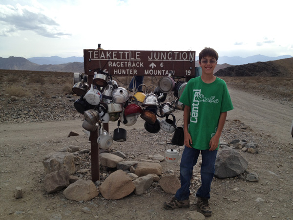
Also, Grant kept asking how much longer it was going to take to get there. I told him it was about 6 miles from Tea Kettle Junction. He asked why it was called that, so I stopped to show him:
Upon arriving, I think Grant was expecting, well, more of a racetrack with cars and stuff. I had him stand in the Grandstand – a really strange rock formation right in the middle of the otherwise flat playa – and told him this was as close to Nascar as we were getting today.
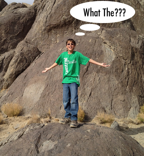
(Just kidding – he knew what he was in for 🙂 )
Initially, I was pretty excited about the location – we had some really sweet looking clouds hovering overhead and I knew it could be good if the sun didn’t get choked out at sunset.
Then I went out and examined the “moving rocks” (they actually move and no one knows why for 100% sure – they think it’s a combination of the wet playa and high winds). Well, they didn’t look so good this time. The trails weren’t as clear as I’d seen in the past and worse, it looks like (despite the signage), that people went walking around out there when the playa was wet and left footprints that might last for YEARS – not cool.
Still, I managed to find a rock with a track that was good and gave it a try.
…But the sun was snuffed out at sunset – no color at all. Just dull grey…
So, it was back to the hotel at the end of our last full day here.
Check out the day’s video to take a ride with us through Titus Canyon, see the Racetrack, and even have a solo from the “Crocodile Man” at the end 😀
~Steve
PS – As always, your comments are welcome 🙂
")

")